Down The History Lane
Western Singapore
This section contains all you need to know about the history of major HDB estates in western Singapore. Here are the links:
Choa Chu Kang
ETYMOLOGY:
Choa Chu Kang was derived from “kang chu”, which the owners of the pepper and gambier plantations were known as.
Chua was clan name of the first headman
Chu – owner or lord
Kang – river
HOW IT LOOKED LIKE IN THE PAST:
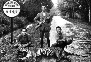
Started as Chua Chu Kang village at the junction of Choa Chu Kang Road and Jalan Sungei Poyan
Mostly gambier and pepper plantations along the riverbank. The people the were largely Teochew speakers and was most notably infested with tigers!
The Hokkiens then moved in – vegetable and poultry farms started. Pineapple, rubber and coconut plantations too.
FUN FACT:
Singapore's last tiger was shot there in 1930!
Bukit Panjang
ETYMOLOGY:
It literally means “long hills” in malay, describing the long range of hills that ended in Bukit Timah.
Was changed to “zhenghua” at a point with the government's campaign to change names of places in Singapore to mandarin. This did not go well with public, so the name was changed back to Bukit panjang.
WHAT IT LOOKED LIKE IN THE PAST:
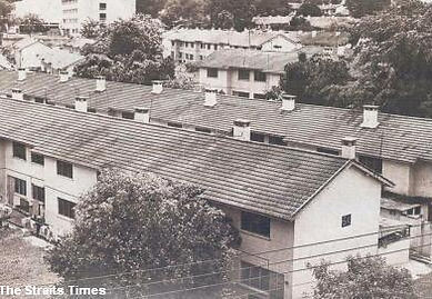
The development of Bukit Panjang started on 15 May 1981. The area used to comprise rural settlements in early 1990's.


Bukit Batok
ETYMOLOGY:
Bukit Batok is an estate located in the west of Singapore. Bukit Batok in English literally means "Coughing Hill".
Malay names:
(1) bukit means "hill" and batok means "coughing". The blasting noises from granite quarrying in the hill sounded very much as if the hill were coughing.
(2) Batok kepala means "skull"
HOW IT LOOKED LIKE IN THE PAST:
Bukit Batok used to be a sleepy rural outback with undeveloped areas that were occupied by forests, farmlands and factories.
HISTORICAL SIGNIFICANCE:
Bukit Batok Hill is located in the Bukit Timah area, where some of the heaviest fighting on the island—the Battle of Bukit Timah took place in early 1942. As a result, in June 1942, the Japanese wanted to build a war memorial and Shinto shrine to commemorate their war dead in the vicinity.
Bukit Batok was significant as the 400-foot (120 m) high hill overlooked the Ford Motor Factory where Lieutenant-General Arthur Ernest Percival, General Officer Commanding, HQ Malaya Command, had surrendered over 125,000 British and Commonwealth troops to Lieutenant-General Tomoyuki Yamashita on the evening of 15 February 1942.


Jurong
ETYMOLOGY:
Jurong is probably derived from the Malay word jerung, which means a "shark".
The first road in the area, Jurong Road was cut around 1852-1853, during the time of John Thomson's tenure as Chief Surveyor.
In the early 1900s, Jurong was uncharted territory, mainly dominated by swamps with low hills covered by shrubs and a thick jungle. The word jurong (jurung in current Indonesian spelling) refers to the elevated porch of a traditional house. Thus considering the area's many small hills in a swamp, Jurong may also refer to these small elevated lands in the swamp.
JURONG EAST HISTORY:
The development of Jurong started in the 1970s when estates such as Boon Lay, Taman Jurong, Bukit Batok, Bukit Gombak, Hong Kah, Teban Gardens and Yuhua were built, mostly due to the resettlement of Hong Kah (present-day Tengah) and surrounding villages. Yuhua, Teban Gardens, Bukit Batok and Bukit Gombak formed Jurong East.
JURONG WEST HISTORY:
The development of Jurong started in the 1970s when estates such as Boon Lay, Taman Jurong, Bukit Batok, Bukit Gombak, Hong Kah, Teban Gardens and Yuhua were built, mostly due to the resettlement of Hong Kah (present-day Tengah) and surrounding villages. Boon Lay, Taman Jurong and Hong Kah formed Jurong West.
HOW IT LOOKEDLIKE IN THE PAST:
Back in the old days, Jurong River was infested with crocodiles and there were hilly jungle with prawn and fish ponds.
HISTORICAL SIGNIFICANCE:
For the local Chinese population, Jurong was formerly called peng kang, a reference to a gambier plantation located in the area. After 1906, rubber plantations dominated the area — Bulim Estate, Lokyang Estate, Chong Keng Estate, Seng Toh Estate and Yunnan Estate, giving rise to many of the local names for areas in Jurong. International Business Park which is Singapore’s first Business Park is also located here.


Bukit Timah
ETYMOLOGY:
The name Bukit Timah came about from a corruption of the name of the Temak tree which grows in the area. Bukit is Malay for "hill"; and Timah is Malay for "tin" and thus the often mistaken belief that the hill holds tin.
HOW IT LOOKED LIKE IN THE PAST:
On 28 June 1827 it was discovered by John Prince, Acting Resident of the Incorporated Settlement that the area was a dense jungle, infested with tigers, and thus Indian convicts were deployed to kill the animals.
By the turn of the century, the area had been cleared although it remained rural with a spread of old kampong housing and a few inhabitants. In the 1900s, the sparsely populated land was famed for giant industries like Cold Storage Dairy Farm, the Ford Assembly Plant and Eveready Batteries, with various premier schools like the University of Singapore, the Chinese High School, the Chinese Girl's High School, The Anglo-Chinese School.
HISTORICAL SIGNIFICANCE:
During World War II, Bukit Timah was the location of Singapore's surrender. The Japanese planned their onslaught measuring their victory with the conquest of Bukit Timah Hill. When Percival surrendered at the Ford Factory off Bukit Timah Road, the Japanese army displayed their victory marching down this road.

Clementi
ETYMOLOGY:
The town was named after the Governor of the Straits Settlements and High Commissioner Sir Cecil Clementi-Smith.
A HISTORY OF SIR CECIL CLEMENTI-SMITH:
Rt Hon* Sir Cecil Clementi-Smith G.C.M.G.** (1840 – February 6, 1916), was a British colonial administrator.
The governor was an accomplished Chinese scholar. Among his great works during his stint in office were laws brought into force to control secret societies in Singapore. Having been a popular governor, the Chinese community petitioned for his continuation as governor when he left Singapore in 1893.
*Right Honourable
** (In the UK) Knight or Dame Grand Cross of the Order of St Michael and St George.
HOW IT LOOKED LIKE IN THE PAST:
Part of Clementi used to be swamp land, while the other areas comprised of villages with cottage industries and a farm.
HISTORICAL SIGNIFICANCE:
The present area occupying Clementi Avenue 1 used to be known as 'Sussex Estate', named after the historic county of Sussex in England. It was developed in the mid-1950s to house the families of British senior non-commissioned officers. When Clementi underwent a major transformation beginning in 1975, Sussex Estate was the only pre-development feature that was retained. It was demolished in 1997.
Most of the present Clementi New Town area used to be occupied by 'Colombo Camp'. It is not known when the camp came into existence. However, the Singapore Guard Regiment, formed in 1948, was stationed there. The regiment was disbanded in November 1971. The camp was demolished in 1975 when the area was cleared for development.