Down The History Lane
Eastern Singapore
This section contains all you need to know about the history of major HDB estates in eastern Singapore. Here are the links:
Serangoon
ETYMOLOGY:
The name was derived from a small marsh bird, the burong ranggong, which was common in the swamps of the Serangoon River. It had a black back, white breast, long, sharp bill, grey crest, long neck and unwebbed feet.
The name Serangoon is derived from the Malay words diserang dengan gong, which means "to be attacked by gongs and drums". People used to go to Benut in Johore through the Serangoon area and had to use gongs to frighten off wild animals and snakes which used to roam the jungle covered area. Serang dengan gong gradually became Serangoon over the years.
HOW IT LOOKED LIKE IN THE PAST:
Tamil Muslim traders from India pioneered the settlement of Serangoon in early 19th century. Serangoon Road was first identified as a bridle path in 1821, and by 1822 it had reached the present Woodsville Corner. A road was proposed in 1822 and by 1827 the road reached the Serangoon River.
The Serangoon district is dotted with plantations which included rubber plantations and other agricultural activities.
HISTORICAL SIGNIFICANCE:
Located in the district of Serangoon are some of Singapore's well-known places including Little India, the original town and settlement for Indians, Bidadari Cemetery, Serangoon Gardens Estate, and today, the new Serangoon (HDB) Housing Estate.
Serangoon Road, together with Upper Serangoon Road, forms a radial arterial road from the city area of Singapore to the Serangoon, Hougang, Sengkang and Punggol areas. For this arterial road, the section from Selegie Road to MacPherson Road is called Serangoon Road, while the section north of MacPherson Road is called Upper Serangoon Road.


Pasir Ris
ETYMOLOGY:
Pasir Ris is likely to be named after a village called Passier Reis, which appeared in 1853. Pasir Hiris (pasir is "sand" and hiris means "to shred" in Malay).
Pasir Ris is near a stretch of white sandy beach and hence it was named “Pasir Ris” which means white sand in malay.
HOW IT LOOKED LIKE IN THE PAST:
In the past Pasir Ris was a low-lying, underdeveloped area with kampongs and villages. There were also many plantations in the area. The beach along the North-East coastline of Singapore is quiet and exudes a resort ambience.
HISTORICAL SIGNIFICANCE:
The beach was a popular resort for water skiing in the 1950s. There was also the Pasir Ris Hotel, venue of many memorable parties and picnic gatherings in the 1950s, 1960s and early 1970s. There were also many villages such as Kampong Pasir Ris, Kampong Bahru and the various Chinese kampongs along Elias Road. The area was well-known for its many plantation estates including the Singapore United Plantations, Loh Lam Estate, Hun Yeang and Thai Min Estates.


Tampines
ETYMOLOGY:
In the past, Tampines was covered by forests, swamp and sand quarries. Ironwood trees, or tempinis, grew abundantly there and thus gave the area its name.
The name Tampines goes back to the Franklin and Jackson map of 1828. It was named after Sungei Tampenus, which in turn got its name from the tampines trees (Streblus elongatus) which were said to be growing there.
HOW IT LOOKED LIKE IN THE PAST:
The area was swampy and was covered by forest and rather undeveloped. Other than that there were some sand quarries in the area.
HISTORICAL SIGNIFICANCE:
In 20th century, Tampines was a rubber plantation. Among the plantations were Teo Tek Ho and Hun Yeang estates. It was part of military training area until about 1987.


Hougang
ETYMOLOGY:
Hougang is the pinyin version of Ow Kang, a Hokkien and Teochew name meaning "river end".
The name Hougang stems from the Hokkien and Teochew word Au-Kang, which refers to the ‘river end’, as Hougang is located upstream or at the back of Sungei Serangoon.
HOW IT LOOKED LIKE IN THE PAST:
In the past, the name connoted the area stretching from the fifth milestone junction of Yio Chu Kang Road and Sengkang Road to the seventh milestone confluence of Upper Serangoon Road and Tampines Road.
There was also a fishing port. The area was once a large piece of deserted land. Farming of pigs was also carried out by farmers. The last of these pig farmers were relocated by the late-1990s to flats built in Hougang. Hougang was a village area that had a large immigrant Chinese community who were mostly Teochew or Hokkien in origin.
HISTORICAL SIGNIFICANCE:
Hougang lies in the large semi-circular balconies which occur in many Housing Development Board public housing flats in the area. Hougang belongs to five political divisions in three different constituencies.

Old Hougang Temple

Famous in Hougang
Old Hougang Temple
Sengkang
ETYMOLOGY:
The area Sengkang was derived from a small road called Lorong Sengkang, off Lorong Buangkok. The Chinese translation for Sengkang is “prosperous harbour”. In the past, the area was known as Kangkar (Chinese: 港脚) or "foot of the port".
The reason why Sengkang was known as Kangkar was because there used to be a fishing port along Sungei Serangoon
HOW IT LOOKED LIKE IN THE PAST:
Sengkang had many pig and vegetable farms located in the area, and it is mainly covered by dense tropical rainforest. The area is highly isolated, and there is hardly any infrastructure there in the past.
HISTORICAL SIGNIFICANCE:
As a result of Sengkang Chinese meaning, the shopping centres and buildings in the area are influenced to have related names such as Compass Point Shopping Centre, Anchorvale and Rivervale, all of which encompass the meaning of a fishing port.
Punggol
ETYMOLOGY:
Punggol, also spelt as Ponggol, means "hurling sticks at the branches of fruit trees to bring them down to the ground" in Malay. Chances are that Punggol was originated as it used to be a farming area.
Kampong Punggol, which was located in the vicinity of the Punggol Jetty, was believed to have existed 200 years ago, even before Sir Stamford Raffles founded Singapore. It was one of the oldest settlements in Singapore. The original settlers were predominantly Malays. Fishing was then the main activity.
HOW IT LOOKED LIKE IN THE PAST:
Punggol had many pig farms and fruit plantation. It was quite rural in the past with no high rise building and infrastructure. The roads usually consisted of dirt tracks.
HISTORICAL SIGNIFICANCE:
During the Second World War in 1942, about 400 Chinese civilians were massacred by the Japanese military forces at Punggol Point, the northern tip of the area, in what was to be known as the Punggol Beach Massacre as part of the Sook Ching Massacre. Today, that location has been marked as a national heritage site.
About 140 years ago, Punggol was populated by Teochews and Catholics. The Teochews were mostly Chinese immigrants who have came to work on farms or plantations. The end of Upper Serangoon Road is known to Teochews as kangkar or "river bank" or "river mouth". Ferries were used on the Serangoon River as transport. An old market was also located here, which was used at a trading place for farm goods. The Catholic missionaries arrived here 140 years ago and set up churches and schools.

Old Punggol Point

An old punggol farm
Old Punggol Point
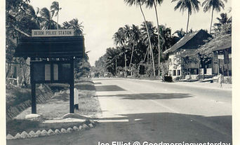
Bedok
ETYMOLOGY:
"Bedok" seems to be a very old place name since in the 1604 Manuel Gomes de Erédia's map of Singapore, there is a reference to the Bedok River called sune bodo (Sungei Bedok).
The Malay word "bedoh" refers to a very large drum, used for calling people to a mosque for prayers or to sound the alarm in the days before loudspeakers. There was a prominent mosque in the 1950s at Jalan Bilal that still uses the drum about five times a day. The "h" in the word bedoh was replaced with a "k", and, as with most Malay words that end with a "k", it is pronounced with an inaudible glottal stop.
A less popular version refers to an equally uncommon Malay term of "biduk", a small fishing boat like the sampan, or more likely, a dugoutcanoe, as the east coast was dotted with many fishing villages.
HOW IT LOOKED LIKE IN THE PAST:
Bedok was once a quiet village. Siglap in the southern part of Bedok, was a vast coconut plantation known as the Siglap Estate that stretched from the beach to Changi Road, and the narrow Siglap Road wound through it from Upper East Coast Road. There were also fishermen who lived on the Siglap stretch of the East Coast beach. The old Siglap 'wet' Market was popular which people in the area, and crowded on Sundays especially for breakfast.
HISTORICAL SIGNIFICANCE:
Bedok Resthouse by the beach was once a popular landmark at the Bedok Junction until the late 1960s. In the immediate vicinity too was a delightful and quaint kampong, nestling comfortably under tall swaying coconut palms and where little chickens ran free. The Upper East Coast Road stretch just before Bedok junction had on the left, old bungalow villas as restaurants famed for its seafood and other Chinese a la carte dishes served in the open-air gardens. On the right of the road, hawker stalls lined the beach, although all that remains of these itinerant stalls is the hawker centre at the start of Bedok Road, rounding the end of Upper East Coast Road.